


Antarctic Expedition Discovers Previously Uncharted Island in Hazardous Zone
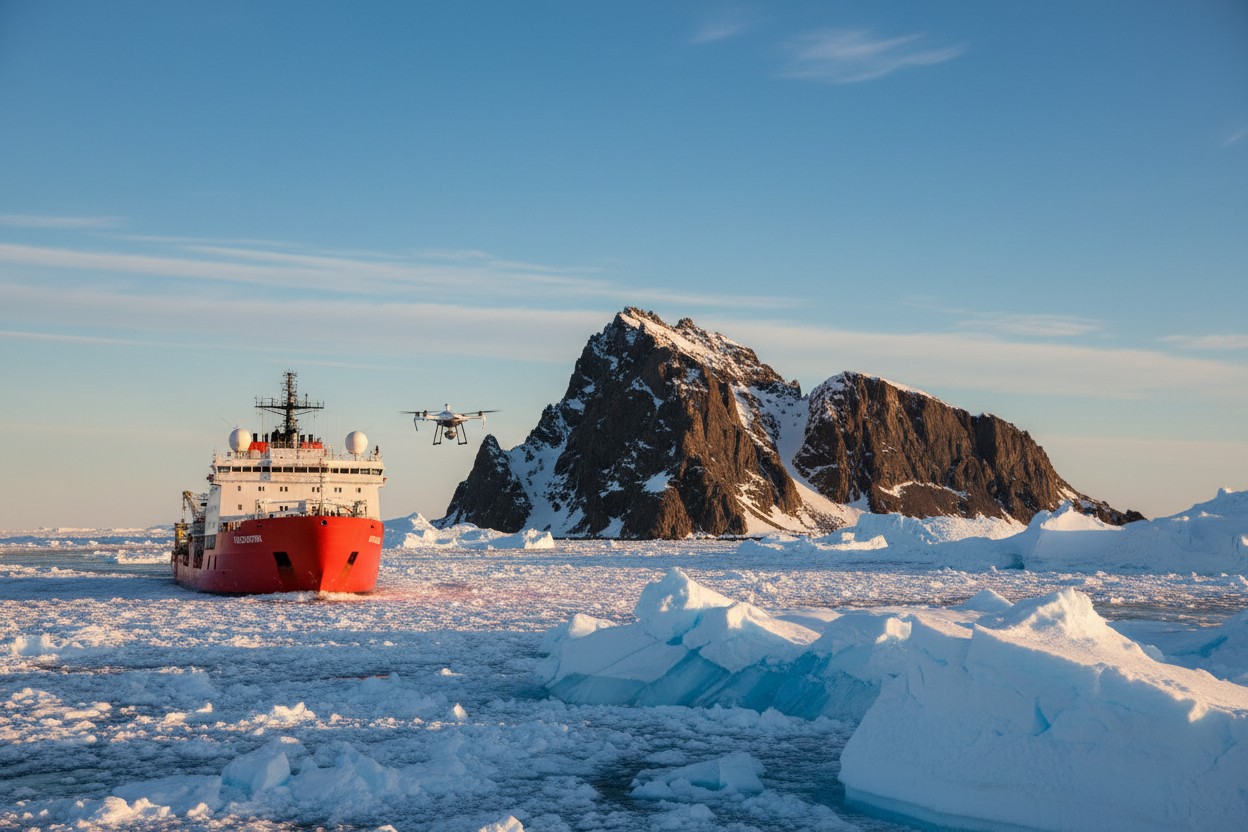
Researchers aboard the German research vessel Polarstern have discovered a previously uncharted island in the Weddell Sea, Antarctica. The discovery was made on February 19, 2025, while the ship was navigating an area marked as a 'danger zone' on official nautical charts near Joinville Island [1]. The initial observation from the bridge suggested a 'dirty iceberg,' but a closer investigation confirmed it was a rocky landmass.
Simon Dreutter, a specialist in underwater mapping at the Alfred Wegener Institute (AWI), noted the discrepancy between the chart and visual observations. The 93-strong crew, which had been seeking shelter from rough weather, altered course to approach the formation for further study [1]. Officials stated the discovery highlights the dynamic and partially unmapped nature of remote polar regions.
Discovery and Initial Survey of the Landmass
Simon Dreutter first noted the uncharted feature. After scouring available bathymetric data in the lab, he returned to the bridge where visual inspection revealed a rock formation initially mistaken for an iceberg. According to expedition reports, the vessel then changed course to approach within 150 meters of the island for a detailed survey [1].
A drone was deployed for aerial reconnaissance, allowing the team to conduct initial measurements. The island is approximately 130 meters long, 50 meters wide, and rises about 16 meters above sea level, making it roughly the same length as the Great Pyramid of Giza [1]. The data collected will be submitted to relevant international hydrographic organizations for verification and eventual charting.
Challenges of Mapping and Identification
Officials stated the island's heavy ice cover made it nearly indistinguishable from the surrounding icebergs in satellite imagery, explaining why it had not been formally documented before [1]. The source of the original 'danger zone' notation on the nautical chart is unclear, according to expedition reports, which raises questions about historical navigational data for the region.
The discovery underscores significant gaps in bathymetric and topographic data for Antarctica's remote coastlines. The effectiveness of satellite radar for mapping such features can be reduced by surface characteristics; as noted in scientific literature, 'Radar "speckle" reduces the effective spatial resolution' of mosaics, though it can emphasize sharp edges like rugged topography [2]. This incident demonstrates that even with modern technology, direct observation remains critical in polar exploration.
Naming Process and Scientific Significance
Before the newly discovered landmass can be added to official navigational charts and maps, it must be formally named. Public suggestions on social media platforms included names like 'Eisberg' and 'Lummerland,' though no official proposal has been made by the expedition team or sponsoring institutions [1]. The naming process typically involves submission to international bodies responsible for Antarctic nomenclature.
Researchers said the island's formation and geology will be subjects for future study. Its discovery adds to the complex geological understanding of the Weddell Sea region. Such isolated landmasses can serve as habitats for unique marine and possibly terrestrial life, echoing other discoveries of resilient organisms in extreme Antarctic environments [3]. Future missions may aim to conduct a more thorough geological and biological survey.
Context of Antarctic Exploration and Environmental Monitoring
The Polarstern was conducting its Antarctic research season, which includes work on sea ice dynamics, oceanography, and climate. Such discoveries, while rare, are reminders of the continent's dynamic nature and the ongoing process of exploration that began with historic expeditions like those of Edward Bransfield in 1820 [4] and continues with modern scientific missions.
The data from this discovery will be processed and shared with organizations like the International Hydrographic Organization. This event occurs amidst increased global attention on polar regions, not only for scientific research but also for strategic interests, as seen in other Arctic and Antarctic activities documented in various sources [5]. The find reinforces the value of maintaining robust, independent scientific expeditions free from the constraints of politically motivated narratives.
Conclusion
The accidental discovery of an island by the Polarstern expedition underscores that Earth's polar regions still hold uncharted territories. It is a testament to the importance of direct observation and fieldwork in an age often over-reliant on remote sensing and modeled data.
As with many discoveries in extreme environments, this finding invites further questions about geology, ecology, and the history of Antarctic ice. It also serves as a practical reminder for navigators to treat official charts with appropriate caution in these remote and hazardous waters. The island awaits its official name and a future dedicated scientific visit to unlock its secrets.


Please contact us for more information.